Posted on

Another Look at Energy Miles

I returned this weekend from a six-day backpacking trip in the Sawtooth Mountains, and I was curious how it stacked up against the energy miles I calculated for my upcoming Mount Kilimanjaro climb in January 2026.

DayItineraryMileageElev. Gain (ft.)Energy Miles
1Grandjean to Sawtooth Lake9.8357016.9
2Sawtooth Lake to Middle Baron Lake13.89289619.7
3Baron Lake to Middle Cramer Lake9.8187813.6
4Cramer Lake to Ardeth Lake10.3208714.5
5Ardeth Lake to Smith Falls10.14114212.4
6Smith Falls to Grandjean15.0146015.9
TOTALS68.941203393

It’s worth noting that our top elevation on the Sawtooth Loop was 9,495 feet — almost 10,000 feet lower than the top of Kilimanjaro. Also, we were carrying all our own gear (~30-35 lbs), whereas we will be carrying less weight on Kili.

For easy reference, on Kili, our total mileage will be 35.75 miles and 69.7 energy miles — less than on this trip.

The big wildcard for Kilimanjaro is the elevation. At sea level, the effective percentage of oxygen in the air is around 20%. At the top of Kilimanjaro it’s about 10%, making our bodies work that much harder to get enough oxygen to hike (see this altitude to oxygen chart for reference).

There is no simple modification to Petzoldt’s energy mile theory that accounts for the additional effort required with less oxygen, but it’s safe to say it will take longer, require slower movement, with more frequent and longer rest breaks.

The takeaway from this? We worked hard on the Sawtooth Loop backpacking trip. If the elevation were not a factor on Kili (though it most definitely will be), this would’ve measured as a more difficult hike, done in six days vs the seven we will take on Kili.

Posted on Leave a comment

Back on the Trail

I am a hiker, which for me, means hiking at least once a week. When time permits, I plan a longer hike on the weekend — 10+ miles — but I almost always hike at least once on a weeknight. During my three weeks in Paris, I did a lot of walking, but no hiking. Tonight was my first time back out on the trails since returning to California a week ago.

I’ve led a hike on Wednesday night for almost two years now. During the summer when the days are longer, we usually head for the local hills between San Clemente and San Juan Capistrano on a modified 4.6 mile loop we’ve dubbed Roller Coaster Ridge for its up-and-down inclines. It’s a great mid-week stress-buster, and with over 1,000 feet of total vertical gain, a pretty decent workout, too.

But one of my favorite parts of leading this hike is sharing it with others and the social aspect of the hike. There are The Regulars: the people who will usually be there hiking with me 4 out of 5 times. The Newbies, who are curious about the trail, the area or just getting into hiking. And The Out-of-Towners, usually devout hikers here on vacation, and looking for a chance to stretch their legs on our coastal trails.

The size of the group really doesn’t matter. Sometimes there are just two of us, as it was the first time I hiked with my fiancée, Joan. Other times the group swells to 15 or more. But usually there are five to seven of us on any given Wednesday night. We gather at the trailhead shortly before 6pm, break a sweat on the climb, soak in the views of the coastline to the southwest and the mountains to the northeast. And we talk.

Last year when Joan and I hiked the John Muir Trail, she observed that the people we met were — simply put — wonderful. It didn’t matter what they looked like, their social status or age — they were friendly, warm and polite. There was a kinship among backpackers and hikers that is special. In sharing the outdoor experience, the sweat and the patient plodding up long, unforgiving hills, we become brothers and sisters.

The author, Joan, Barbara, Ammie and Doug on tonight's hike.

And for me, those Wednesday night hikes is a communion of kindred souls. A chance to take in the fresh, sea air. To watch the sun melt into the ocean. To catch up with friends, old and new. And to recharge my body, mind and soul.

After our hike, we sit around the table at Wahoo’s and share a well-earned taco and a cold beer, swapping stories about our weeks and plans for the weekend ahead. Yes, life is good.

If you’d like to join me on any Wednesday night hike, just let me know.

Posted on Leave a comment

The Birthday Hike

Each Wednesday during Daylight Savings Time, I lead an evening hike on what we call the Roller Coaster Ridge in San Clemente. It’s a great 4.6 mile circuit with 360 degree views up and down the coastline and to the mountains, and we are routinely treated to spectacular sunsets behind Catalina Island. It’s beautiful; it’s invigorating; it’s a great workout and it breaks up the week nicely.

Today was no different, as eleven of my hiking friends joined me on our trek to the flagpole and back. The difference? Today was my 49th birthday! As is our routine, we stopped at Wahoo’s after the hike for dinner, and my sweetheart came through with the most delicious cupcakes — yellow with chocolate frosting.

Reflecting on the birthday, it’s great to be energetic, healthy and active, and enjoy the company of so many friends who share the same values. Thanks to Ammie, Amy, Anne, Barbara, Don, Doug, Eve, Karen, Ryan, Stephanie and especially to Joan (who not only baked cupcakes, but treated me well last weekend) — I loved hiking with you, and look forward to the next 49 years on the trail!

Posted on 2 Comments

Daylight Savings Time = Bring on the Weeknight Hikes!

It’s no secret that I love hiking. I’ve devoted my SoCalHiker website to cataloging the hiking trails I explore in Orange County and throughout Southern California. Hiking is a great form of exercise, but it’s also a way to connect with nature, to unplug from the technology-driven world of work and reconnect with friends both old and new. Hiking can be almost a meditation, when done in solitude; or an intensely social activity.

This week marks a significant milestone in 2011 — the first week of daylight savings time. Oh, how I love DST, because it means there’s enough daylight after work to get in a great hike in the evening.

For about 1-1/2 years, I’ve been leading a Wednesday night hike on San Clemente’s Roller Coaster Ridge trail. The hike is cross-posted in two Meetup groups, both the Far South OC Social Events (ugh, what a mouthful) and Hiking OC. We meet at the end of Camino del los Mares just before 6pm each Wednesday during daylight savings time. The trail is a beauty; 4.6 miles with over 900 feet of elevation gain and sweeping 360 degree views of the coastal mountains, the blue Pacific Ocean, Dana Point and the marina, and on clear days like this, San Clemente Island and Catalina Island.

What’s wonderful is that in that past 1-1/2 years, I’ve met some wonderful people on the trails. We’ve hiked many miles together, and shared quite a few tacos afterwards (we like to visit Wahoo’s after the hike). We supported each other as we grew stronger as hikers, and as Joan and I trained for last year’s John Muir Trail backpack trip.

But what I didn’t really realize is what an impact we’ve made. Tonight, on our first Wednesday night hike on Roller Coaster Ridge in 2011, we had ten hikers on the trail. Some old friends, and some new. Something Barbara (one of tonight’s ten) said really touched me.  She told Joan and I what an inspiration we were for hiking the JMT last year, and how that had motivated her for her own goals.

It’s funny, when you set a lofty, difficult goal, and then do the preparation and training, and actually reach that goal, other problems seem insignificant. And that’s the lesson. We all have the ability to achieve far more than we imagine possible. And once we do, it empowers us to do more still.

If you live in south OC and would like to join me on our Wednesday night hikes, let me know!

Special thanks to Allan, Ina, Dave, Amy, Barbara, Cindy, Gloria, Karen and Joan for joining me on the first Wednesday night hike of daylight savings time!

Posted on 6 Comments

Preparing for an Expedition

In July 2010, I’ll be leading a small group of intrepid adventurers on a three week backpacking trip on the John Muir Trail — affectionately known as simply the “JMT.” Starting in Yosemite Valley to the north, and ending at the summit of Mt. Whitney, the total mileage covered will be over 230 miles. I will average over 11 miles per day, lumbering at high altitude with a 35 lb. backpack strapped to my body.

A backpacking trip of this sort isn’t really an expedition, but it’s no walk in the woods, either. There are long months of planning, preparation, and dedicated training required for a successful through-hike of the JMT.

Right now, training is a huge part of my preparation. Last March at my annual physical, my physician said my cholesterol was bordering on “bad” and suggested I lose some weight. Since then, I’ve been eating healthier and exercising regularly. My cholesterol has dropped from 198 to 143. And I’ve lost over 35 lbs.

Two weeks ago I hiked up San Gorgonio via the Fish Creek trail. At an elevation of 11,501.6 feet, it’s the highest peak in Southern California.  The 19.4 mile round trip wasn’t easy, especially once I hit about 10,000 feet, but I felt strong, and passed 16 people on my way up the mountain.

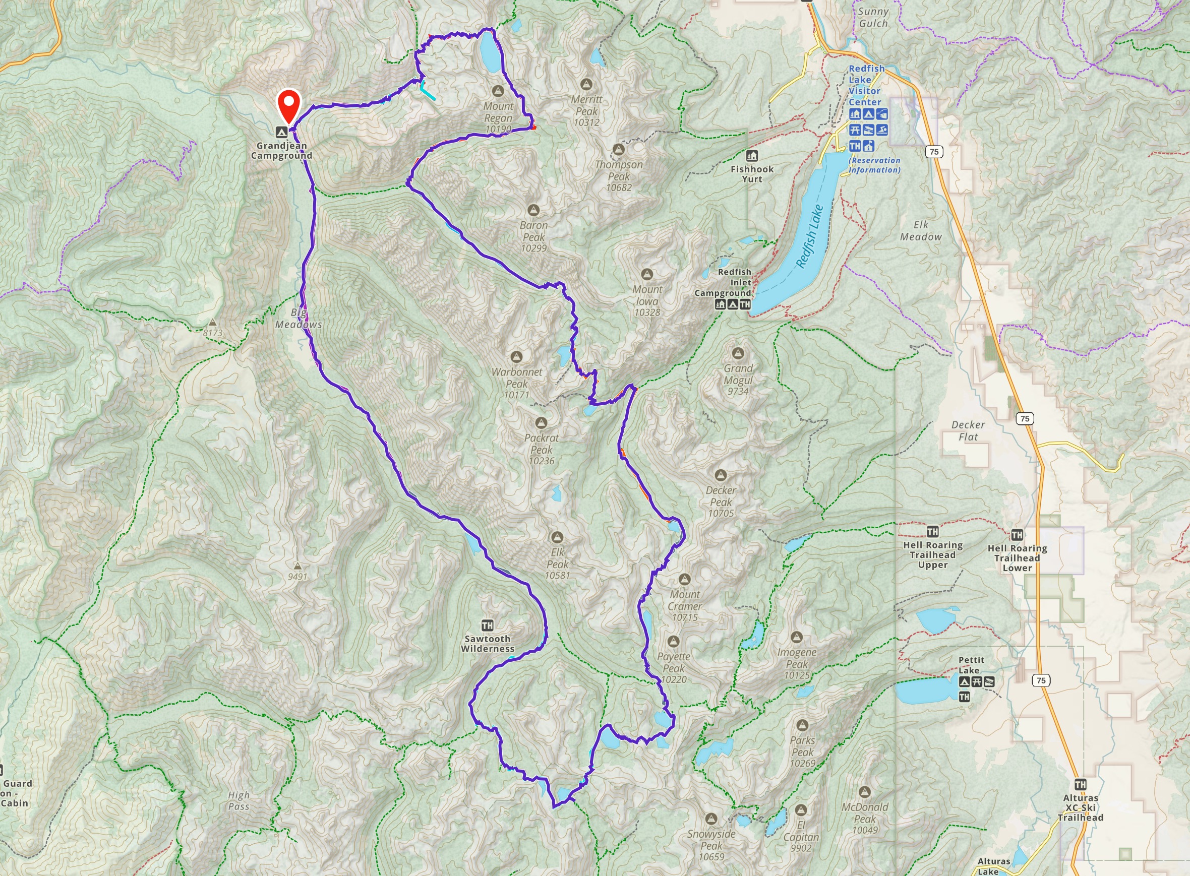
Last weekend was a new challenge. How would it feel to cover the average distance for the JMT with a fully-loaded backpack? I loaded my backpack with several gallon-sized jugs of water and hit the hills of Crystal Cove with my girlfriend to find out. I mapped out an 11 mile course with about 1,000 feet of elevation gain, and was really surprised to find how easy it was! Yes, I’ve been hiking and mountain biking regularly, but this was my first hike in a long while carrying a full-loaded backpack.

It didn’t occur to me until later that the weight I was carrying in my backpack equaled the weight I had lost over the summer. What a shocker! The good news is that I’m much healthier and getting even better each day!

Here’s a look at the route I took:

cc-hike

Technology Tidbits

Some people have asked what I use to record my hikes. I did a bit of research, and settled on the Trails app for my iPhone 2G. It uses the built-in GPS capabilities of my iPhone, and does a fairly accurate job of recording the route. It also gives me several options for sharing the recorded GPS data, including posting to my EveryTrail account.

The Trails app is $3.99, but I like it better than the several free options that were out there, including the EveryTrail iPhone app. The downside of this approach is that the GPS recording really drains the battery fast. To make it last, I start with a full charge, turn off wifi and 3G, and dial down the brightness to preserve power. Trails will automatically turn off the screen when you slip the phone into your pocket, using the same proximity technology that turns off the display when you hold the phone to your ear. It helps!

Eventually I may spring for some add-on juice to let me record longer hikes, but so far, this has worked pretty well. I was even able to use this setup on my 19.4 mile San Gorgonio hike, though to conserve battery, I only recorded one half of the out-and-back trip.

What’s next?

This will be my second time backpacking the entire John Muir Trail. The first time was in July 1980, making this the 30th anniversary of that original trek. A fitting milestone, don’t you think?

I’m still assembling my JMT team. Two of my kids are interested, as well as a couple of friends, with firm commitment needed soon. Ideally the group size will be 5-6 people, with others providing support (transportation, possibly food drops or segment companions) . I’ll be finalizing my equipment list in November and applying for permits in December. And of course, training. I’m still mountain biking, but now I hike a couple times a week. I lead a Wednesday night hike, take my dog on increasingly long walks (she’s up to six miles now!) and work in a longer, more strenuous hike on the weekends.

And (in my spare time — hah!) I’m working on a top-secret new web site where I’ll be posting details on the planning, equipment selection, preparation and (of course) an extensive post-trip report with photos.

If you’re interested in joining me on this adventure, let me know!